GPS Map Camera APK: A Comprehensive Guide to Geotagging Your Photos
The GPS Map Camera APK is transforming mobile photography by effortlessly merging geotagging with a user-friendly interface. Available on Google Play, this Android app enriches photos with precise geographical details, turning them into dynamic records of your journeys. It's more than just an app; it's a tool that redefines how we document and share travel memories. By embedding accurate location data into image metadata, GPS Map Camera helps photographers delve deeper into their experiences.
Why Users Love GPS Map Camera
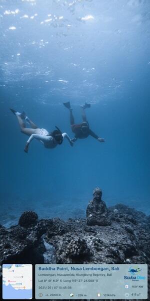
GPS Map Camera's standout feature is its highly accurate geotagging. Users appreciate its ability to pinpoint exact locations, ensuring each photo accurately reflects its origin. This precision is vital for personal recollections and professional applications alike. Real estate agents, travelers, and researchers find it invaluable for reliable location documentation and revisits.

The app also shines in its efficiency, automating location data addition for increased productivity. Its growing user base, evident in its app store popularity, consistently praises its ease of use and the enhanced detail it brings to shared memories. Whether for personal enjoyment or professional use, GPS Map Camera's functionality makes it a go-to app for digital photographers.
How GPS Map Camera APK Works
- Installation: Download the latest version of GPS Map Camera from Google Play onto your Android device.
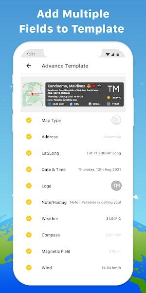
- Template Selection: Launch the app and select either the "Advance" or "Classic" template to personalize your user interface.
- Stamp Customization: Customize the appearance of GPS geo-location stamps, adjusting date, time, and other metadata formats.
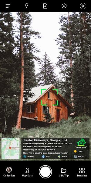
- Camera Settings: Fine-tune camera settings such as grid lines, aspect ratio, flash, and focus for optimal photo quality.
- Automatic Geotagging: The app automatically embeds precise GPS data into your photos' metadata during capture.
Advertisement
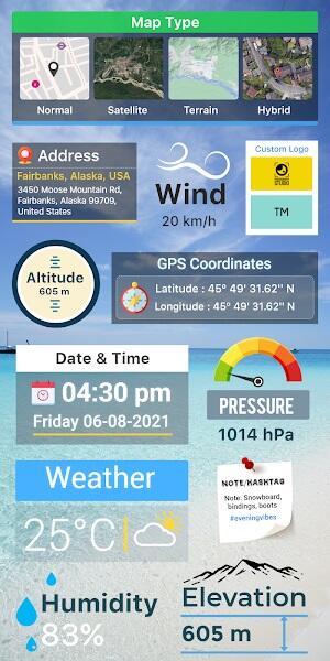
Key Features of GPS Map Camera APK
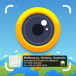
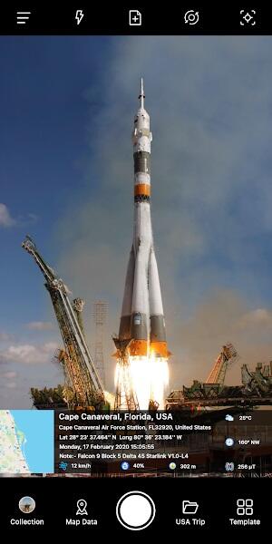
- Precise Geotagging: Embeds exact GPS coordinates into photo metadata.
- Customizable Map Views: Offers Normal, Satellite, Terrain, and Hybrid map options.
- Address Display: Automatically or manually adds the location address.
- Latitude/Longitude: Displays coordinates in DMS or decimal format.
- Date & Time Stamps: Customizable date and time stamps with various formats.
- Logo Integration: Allows uploading a custom logo for branding.
- Notes, Hashtags, Weather Data, Compass Direction, Magnetic Field, Wind Speed, Humidity, Pressure, Altitude, and Accuracy: Provides comprehensive location-based data.
Advertisement
Tips for Optimal GPS Map Camera Usage
- Enable Location Services: Ensure your device's location services are enabled for accurate geotagging.
- Review Privacy Settings: Carefully consider privacy implications before sharing geotagged photos.
- Calibrate Compass: Regularly calibrate your device's compass for accurate directional data.
- Utilize Hashtags: Employ relevant hashtags for improved visibility and organization.
- Explore Advanced Settings: Delve into the advanced settings to fully customize the app's functionality.
By following these tips, you can maximize GPS Map Camera's potential, enriching your photography with valuable geographical context.
Conclusion
GPS Map Camera is an essential tool for photography enthusiasts and explorers. Its seamless integration of geographical data elevates visual storytelling. Download the GPS Map Camera MOD APK to enhance your photographic content, making each image both visually appealing and information-rich.